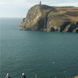
Overcast, misty and coolish as we drove to Castletown
to carry on where we'd left off yesterday. After leaving the town behind us we followed the path at sea level past a water-filled disused limestone quarry, with large lime kilns on the rocks, unusual rock formations:

and onto the Scarlett Point Nature Reserve. As we were passing a notice that said Radio Ham tower, a face popped up over the wall and we were invited inside to view the surroundings. Ronnie has taken over maintenance of the tower and was currently up a ladder doing some DIY weather-proofing when he heard us passing.The tower is his radio base and has 2 webcams on the top giving panoramas of this part of the coast http://www.scarlettpoint.com/
Ronnie up in the tower.
The weather improved as we skirted the low level coast and walked into Port St Mary with its Victorian raised walkway above the beach
The day just got better and better as we discovered a great cafe for lunch, next to the art-framing shop and this gave us today's :
Word of the Day ( verb ) - to " oooooooooo-gull " - to gaze longingly and droolingly at the array of cakes contained within, knowing that you still have another 7 miles to go and can't possibly indulge without really regretting it later on.
After lunch we wandered on into the National Trust area of Public Ramblage beyond Port St Mary - the area of the Chasms - great rifts in the earth caused by severe earth movements, and the Sugarloaf - the island's finest sea stack.
Bay Stacka with the Sugarloaf

Gazing into the abyss
and they probably spotted us in the Sound cafe eating scones ( as we now didn't have too far to go and so could indulge )
Bradda Head and the Milner Tower came into view next, meaning we were almost home to Port Erin
As usual the evenings were spent investigating transport issues


No comments:
Post a Comment